Last Updated on 02/07/2026
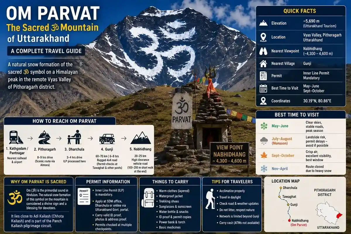
Somewhere in the high Himalayas of Uttarakhand, snow falls on a mountain face in a pattern that looks unmistakably like the Sanskrit symbol ॐ. This isn’t a myth passed down through generations — it’s a real, photographed, GPS-located snowfield on Om Parvat, and it draws pilgrims and trekkers from across India every year.
If you’re planning a trip here, here’s what you need to know upfront: Om Parvat sits in the remote Vyas Valley of Pithoragarh district, close to the Indo-Tibet border, and it’s viewed from a spot called Nabhidhang. Good news for anyone worried about a punishing trek — a motorable road now takes you almost all the way, so no multi-day trekking is required.
Quick Facts:
- Elevation: ~5,690 m (as per Uttarakhand Tourism)
- State: Uttarakhand
- District: Pithoragarh
- Location: Vyas Valley
- Approx. Coordinates: 30.19°N, 80.86°E
- Nearest Viewpoint: Nabhidhang (~4,300–4,600 m)
- Nearest Village: Gunji
- Nearest Helipad: Gunji / Dharchula (seasonal)
- Nearest Hospital: Dharchula Community Health Centre
- Nearest Police Post: Dharchula / Tawaghat checkpoints
- Permit Requirement: Inner Line Permit (mandatory)
- Best Season to Visit: May–June, September–October
Why Om Parvat Is Considered Sacred
For Hindus, Om (ॐ) is the primordial sound — the vibration believed to underlie creation itself. Seeing that exact symbol appear naturally in snow, on a mountain face, without any human hand involved, is why devotees treat a clear darshan here as deeply auspicious.
The mountain sits close to Adi Kailash (also called Chhota Kailash), one of the five sacred Panch Kailash peaks associated with Lord Shiva. Most pilgrims combine both destinations in a single yatra, since they lie along the same Byans Valley route that historically formed part of the old Kailash Mansarovar pilgrimage corridor toward Tibet.
What most people don’t realize is that the Om pattern isn’t fixed — it’s seasonal snow deposition, so its clarity shifts with weather, wind, and how much snow has recently fallen. A hazy or partial Om isn’t unusual; a fully crisp symbol is what everyone hopes for, and patience often pays off if clouds are in the way.
Best Time to Visit Om Parvat
| Season |
Conditions |
| May–June |
Clear skies, stable roads, peak season — most popular window |
| July–August (Monsoon) |
Landslide risk, unpredictable permit delays — avoid if possible |
| September–October |
Crisp air, excellent visibility, considered the best window by many operators |
| November–April |
Route closed due to heavy snow |
The yatra season typically opens in early May and runs until mid-October, subject to road conditions and government clearance each year.
How to Reach Om Parvat
Getting here is a multi-stage journey, but none of it requires technical trekking. Here’s the realistic route:
- Reach Kathgodam or Pantnagar. Kathgodam is the nearest railhead (trains from Delhi); Pantnagar has the nearest airport with limited flights.
- Drive to Pithoragarh. This leg covers roughly 8–9 hours through the scenic Kumaon hills, passing Bhimtal and Almora.
- Continue to Dharchula. About 90 km and 3–4 hours from Pithoragarh. This border town is where your Inner Line Permit gets processed.
- Drive to Gunji. A rugged 4×4 stretch of roughly 60–70 km, taking 6–8 hours with permit checks along the way at Tawaghat and other posts.
- Gunji to Nabhidhang. The final 20–25 km stretch by high-clearance vehicle brings you to the Om Parvat viewpoint. In most seasons, this is now fully motorable, with only a short 100–200 metre walk needed at the end for the clearest sightline.
Total distance from Delhi works out to roughly 650–700 km, and most yatra packages build in 2–4 days for the full journey, including acclimatization stops.
Note on road conditions: The Gunji–Nabhidhang stretch is maintained by the Border Roads Organisation (BRO) and can shut temporarily after landslides or early snowfall. Confirm current road status with KMVN or your operator a day or two before departure, especially outside the peak May–June window.
Permits: What You’ll Actually Need
Because Nabhidhang sits in a restricted border zone, an Inner Line Permit (ILP) is mandatory for every Indian traveller heading beyond Dharchula.
- Where to apply: The SDM office in Dharchula, through the official Pithoragarh district portal (pass.pithoragarh.online), or via an authorised yatra operator
- Documents needed: Valid photo ID (Aadhaar/passport), passport-size photographs, a medical fitness certificate, and address proof
- Checkpoints: Expect permit verification at multiple posts — Tawaghat, Kalapani, and Nabhidhang among them — so carry physical copies, not just digital ones
- Foreign nationals: This route is currently restricted mostly to Indian citizens; foreign travellers should check current Ministry of Home Affairs guidelines before planning, since rules here change without much notice
One mistake many travellers make is assuming a helicopter booking skips the permit process — it doesn’t. Every yatri, regardless of transport mode, needs valid ILP documentation.
What to See Around Om Parvat
Since you’re already deep in the Byans Valley, it makes sense to combine Om Parvat with nearby sacred and scenic spots on the same trip:
- Adi Kailash (Chhota Kailash): A 6,000+ metre peak resembling the original Mount Kailash, viewed from Jolingkong
- Parvati Sarovar: A high-altitude lake near Adi Kailash, believed to be linked to Goddess Parvati
- Kalapani: Home to an ancient Kali Mata temple, believed to mark the origin of the Kali river
- Vyas Gufa: A cave associated with sage Ved Vyas, said to be where parts of the Mahabharata were composed
- Kuti Village: The last inhabited village on this route, connected in local legend to the Pandavas’ exile
- Lipulekh Pass: A further 7–8 km beyond Nabhidhang, this high pass on the India-Tibet border was historically used for trade and forms part of the old Kailash Mansarovar route; access here is even more tightly restricted and not part of standard Om Parvat itineraries.
Temples & Sacred Sites Along the Route
The road to Om Parvat passes through Kumaon’s spiritual heartland, so it’s worth building in stops at these sites if time allows:
- Patal Bhuvaneshwar Cave Temple: A limestone cave shrine near Gangolihat, believed to be discovered by Adi Shankaracharya and considered equal in merit to visiting the Char Dham. Located roughly 90 km from Pithoragarh, slightly off the main Om Parvat road.
- Haat Kalika Temple, Gangolihat: One of Kumaon’s revered Shaktipeeth temples, dedicated to Goddess Kali.
- Kali Mandir, Kalapani: An ancient shrine believed to mark the origin of the Kali river, and a mandatory permit-check halt on the way to Nabhidhang.
- Narayan Ashram: A meditation retreat near Pithoragarh founded by Narayan Swami in 1936, popular with pilgrims seeking a quiet stop before the high-altitude leg begins.
- Nanda Devi Temple, Pithoragarh: A town-centre temple dedicated to the region’s presiding goddess, easy to visit while you wait for permit processing.
Practical Tips for Your Om Parvat Trip
- Acclimatize properly. You’ll be climbing from lowland heat to over 4,000 metres in a few days — rest at Pithoragarh, Dharchula, and Gunji rather than rushing through.
- Pack for sudden cold. Even sunny days at Nabhidhang carry a sharp wind chill; layered thermal wear is non-negotiable.
- Book accommodation early during peak months. May–June and September–October see the heaviest footfall, and options in Gunji and Dharchula are limited to KMVN guesthouses, homestays, and basic camps.
- Carry cash. ATMs are unreliable or absent beyond Dharchula.
- Travel with a registered operator or group if this is your first high-altitude yatra — logistics, permits, and altitude monitoring are far smoother with local support.
Om Parvat Trip Budget
| Style |
Approx. Cost (per person) |
Includes |
| Budget (self-organized) |
₹12,000–18,000 |
Shared transport, KMVN guesthouses, basic meals |
| Mid-range (group package) |
₹20,000–30,000 |
Private 4×4, homestays/camps, permit assistance |
| Premium (private/helicopter add-on) |
₹40,000+ |
Dedicated vehicle, better lodging, guided support |
Costs vary by season and operator — always confirm what’s included (permits, meals, transport) before booking.
What to Pack
- Layered thermal wear, windproof jacket, and gloves — even summer mornings at Nabhidhang are cold
- Sturdy trekking shoes for the short walks at viewpoints
- Sunglasses and high-SPF sunscreen — UV exposure is intense at altitude
- A basic first-aid kit with altitude sickness medication (consult your doctor beforehand)
- Power bank — charging points are scarce beyond Dharchula
Health & Connectivity at High Altitude
Altitude Mountain Sickness (AMS) is a genuine risk above 3,500 m. Watch for headaches, nausea, or breathlessness, and don’t push through them — descend and rest if symptoms worsen. Basic medical aid is available at Dharchula and Gunji, but serious cases require evacuation to Pithoragarh, so don’t attempt this trip if you have existing heart or lung conditions without medical clearance.
Mobile network is limited to BSNL/state carriers beyond Dharchula, and coverage often disappears entirely near Gunji and Nabhidhang. Inform family of your rough schedule before you lose signal.
Distance & Route Chart
| Leg |
Distance |
Approx. Time |
| Delhi to Kathgodam |
~285 km |
6–7 hrs (train/road) |
| Kathgodam to Pithoragarh |
~210 km |
8–9 hrs |
| Pithoragarh to Dharchula |
~90 km |
3–4 hrs |
| Dharchula to Gunji |
~60–70 km |
6–8 hrs |
| Gunji to Nabhidhang (Om Parvat viewpoint) |
~20–25 km |
1–2 hrs |
Sample Day-Wise Itinerary
- Day 1: Delhi to Kathgodam (train/road)
- Day 2: Kathgodam to Pithoragarh, acclimatize
- Day 3: Pithoragarh to Dharchula, collect Inner Line Permit
- Day 4: Dharchula to Gunji via Tawaghat and Kalapani
- Day 5: Gunji to Nabhidhang for Om Parvat darshan, return to Gunji
- Day 6–7: Return journey to Dharchula, Pithoragarh, and back toward Kathgodam/Delhi
Most operators extend this by 1–2 days to include Adi Kailash darshan from Jolingkong.
Emergency Contacts & En-Route Facilities
- Medical help: Basic health centres at Dharchula and Gunji; the nearest full-facility hospital is in Pithoragarh. Dial 108 for ambulance service anywhere in Uttarakhand.
- Police/ITBP posts: Located at Tawaghat, Kalapani, and Nabhidhang for permit checks and emergencies. Dial 112 for police anywhere in the state.
- Fuel pumps: Last reliable fuel stop is Dharchula — carry a reserve can if travelling beyond in your own vehicle.
- ATMs: Available in Pithoragarh and Dharchula only; none beyond that point.
- Tourist helpline: Uttarakhand Tourism’s helpline (1364) can assist with general yatra queries; for landslide or disaster-related road closures, the State Emergency Operation Centre can be reached at 1070.
Weather By Month
| Month |
Conditions |
| May–June |
Mild days, cold nights, generally stable roads |
| July–August |
Monsoon rain, higher landslide risk |
| September–October |
Clear skies, cold, best visibility |
| November onward |
Snowfall begins, route closes for the season |
Photography & Drone Rules
Personal photography is allowed at Nabhidhang and along the route, but this is a sensitive border zone — avoid photographing ITBP posts, checkpoints, or military installations. Drones are effectively banned in this corridor given its proximity to the international border; carrying one can create serious permit complications, so leave it at home.
Om Parvat vs Adi Kailash: What’s the Difference?
They’re often visited together, but they’re not the same thing. Om Parvat is a snow-marked peak viewed from Nabhidhang, while Adi Kailash (Chhota Kailash) is a separate, taller peak viewed from Jolingkong, considered a stand-in for the original Mount Kailash in Tibet. Most 6–8 day yatra packages cover both, since they lie along the same Byans Valley corridor.
Common Mistakes to Avoid
- Skipping the medical fitness check — it’s required for the ILP and genuinely matters given the altitude.
- Underestimating weather windows — clouds can roll in fast at Nabhidhang; don’t rush your visit if the sky hasn’t cleared yet.
- Ignoring buffer days — landslides and permit delays are common enough that a rigid itinerary can fall apart; build in 1–2 spare days.
- Assuming this is a casual day trip — it’s a genuine high-altitude journey, not a weekend hill-station outing.
FAQs About Om Parvat
Q-1: What is the height of Om Parvat?
Uttarakhand Tourism lists it at approximately 5,690 metres. Some sources cite figures closer to 6,190 m, but that number usually belongs to the neighbouring Adi Kailash peak.
Q-2: Where is Om Parvat located?
Om Parvat lies in the Vyas Valley of Pithoragarh district, Uttarakhand, close to the Indo-Tibet border.
Q-3: Do I need to trek to see Om Parvat?
No long trek is required. The Nabhidhang viewpoint is now road-accessible, with only a short walk of a few hundred metres at most.
Q-4: Is a permit required to visit Om Parvat?
Yes, an Inner Line Permit from the Dharchula SDM office is mandatory for all Indian travellers heading beyond Dharchula.
Q-5: What is the best time to visit Om Parvat?
May–June and September–October offer the clearest skies and most stable road conditions for viewing the Om formation.
Q-6: Can Om Parvat and Adi Kailash be visited together?
Yes, most yatra packages combine both, since they sit along the same Byans Valley route and are typically covered in one 6–8 day trip.
Q-7: Is Om Parvat open to foreign tourists?
This route is primarily open to Indian citizens due to its border-sensitive location; foreign nationals should check current government guidelines before planning.
Q-8: How far is Om Parvat from Delhi?
The full journey covers roughly 650–700 km one way, typically taking 2–4 days including acclimatization stops.
Q-9: What is the significance of the ॐ symbol on Om Parvat?
Om is considered the primordial sound in Hindu tradition, so its natural appearance in snow is seen as a rare, auspicious sign rather than a coincidence.
Q-10: Is the Om symbol visible all year round?
No — visibility depends on seasonal snowfall and weather. It’s clearest during the May–June and September–October windows and often obscured in winter and monsoon.
Q-11: What is the ideal duration for the Om Parvat yatra?
Most packages, including Adi Kailash, run 6–8 days from Kathgodam or Delhi and back, factoring in acclimatization and permit checks.
Q-12: Is the Om Parvat route safe for senior citizens?
Yes, since the road now reaches close to the viewpoint with minimal walking, but seniors should get a medical check and travel with an experienced operator.
Q-13: What is the nearest airport to Om Parvat?
Pantnagar Airport, roughly 450 km away, is the nearest airport, though flight frequency is limited and mostly connects to Delhi.
Q-14: Can solo travellers do the Om Parvat yatra?
It’s technically possible, but most operators and local authorities recommend joining a group due to permit logistics, altitude risk, and limited solo infrastructure in the border zone.
Q-15: What is Om Parvat trip cost for a group package?
Mid-range group packages typically cost ₹20,000–30,000 per person, covering transport, permits, and stays; budget options can run lower for self-organized trips.
Q-16: What altitude sickness precautions should I take for Om Parvat?
Acclimatize gradually at Pithoragarh, Dharchula, and Gunji, stay hydrated, avoid alcohol, and carry AMS medication after consulting a doctor.
Q-17: Which is better for viewing Om Parvat — May–June or September–October?
Both work well; September–October is often rated slightly clearer by operators, while May–June suits those wanting warmer overall weather.
Q-18: Can I visit Om Parvat without joining a registered tour operator?
Yes, independent travel is allowed, but you’ll still need to secure the same Inner Line Permit and arrange your own 4×4 transport and accommodation.
Q-19: What is the difference between Om Parvat and Adi Kailash?
Om Parvat is the snow-marked peak seen from Nabhidhang; Adi Kailash is a separate, taller peak viewed from Jolingkong and considered a stand-in for Mount Kailash in Tibet.
Q-20: When does the Om Parvat yatra season open and close each year?
The season typically opens in early May and closes by mid-October, though exact dates are announced annually by KMVN based on road and weather conditions.
Q-21: Can Om Parvat be visited by bike?
Experienced riders do attempt this route on motorcycles, but it demands strong off-road skill, proper gear, and the same Inner Line Permit as any other traveller.
Q-22: What does an Om Parvat tour package typically include?
Most packages cover transport from Kathgodam or Delhi, permits, accommodation in Gunji/Dharchula, meals, and guided darshan at Nabhidhang and Jolingkong.
Q-23: Is there a map or fixed route for the Om Parvat yatra?
Yes, the fixed route runs Kathgodam–Pithoragarh–Dharchula–Gunji–Nabhidhang, and all permits and checkpoints follow this same corridor.
Q-24: What is the road condition like on the way to Om Parvat?
Roads are paved and reasonable up to Dharchula, then turn into rugged, BRO-maintained mountain tracks beyond Tawaghat that require a 4×4 vehicle.
Conclusion
Om Parvat isn’t a destination you stumble upon — it takes permits, planning, and a genuine respect for high-altitude travel to get there. But for those who make the journey, that first clear glimpse of the ॐ symbol resting naturally in Himalayan snow tends to stay with them long after the trip ends. If you’re building a Kumaon itinerary, pair this sacred summit with Adi Kailash, book your Inner Line Permit early, and aim for the September–October window if clear mountain views matter most to you.
Suggested Tour:

 Call
Call WhatsApp
 Enquiry