Last Updated on 11/07/2026
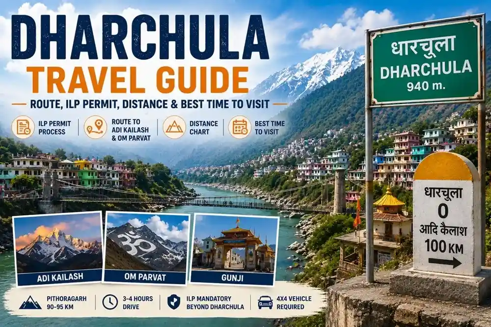
Dharchula, Uttarakhand is a small border town in Pithoragarh district, at roughly 940 metres on the banks of the Kali (Mahakali) River, with Nepal visible on the opposite bank. This Dharchula travel guide covers what pilgrims need before heading toward Adi Kailash, Om Parvat, or the Kailash Mansarovar Yatra via Lipulekh Pass — permits, route, weather, and stay options.
Planning a trip in 2026? Anyone travelling beyond Dharchula toward the restricted Adi Kailash, Om Parvat, Gunji, or Lipulekh region needs the necessary permits arranged here first.
Quick Overview
- Dharchula is the last major town before the Indo-Tibet border restricted zone.
- Located at 940 m altitude, about 90–95 km (3–4 hours) from Pithoragarh.
- Inner Line Permit (ILP) is mandatory for Adi Kailash, Om Parvat, Gunji, and Lipulekh Pass.
- Best time to visit: May–June and September–October.
- Avoid monsoon due to landslides and travel delays.
Where Is Dharchula and Why It Matters
This tehsil headquarters in the Kumaon Himalaya is split by the Kali River — Indian territory on one bank, Nepal’s Darchula town on the other. Eligible Indian and Nepali nationals benefit from the long-standing open-border arrangement here, subject to current rules.
Permit verification happens at multiple checkpoints beyond this town, toward Gunji. The town itself needs no permit — only the onward journey into the restricted Byans and Vyas Valley does.
Things to Do in Dharchula
Beyond being a permit stop, Dharchula rewards a short walk around. The local market near Naya Bazar sells Kumaoni woolens, dried apricots, and honey. The Kali River viewpoint near the suspension bridge looks across to Nepal’s Darchula town. Narayan Ashram, a short drive out, offers quiet valley views. In November, the Jauljibi Mela — a historic trade fair — is worth the detour.
Route to Adi Kailash and Om Parvat
Two separate pilgrim routes branch out from Dharchula, easy to confuse:
- Adi Kailash route: Dharchula → Tawaghat → Gunji → Kuti → Jolingkong (Adi Kailash base).
- Om Parvat route: Gunji → Kalapani → Nabhidhang, viewpoint for the sacred “Om” snow formation.
Both share the stretch to Gunji, then split. Beyond Dharchula, roads narrow and are restricted to authorised 4×4 vehicles. Dharchula–Tawaghat (19 km) takes ~45 minutes; Tawaghat–Gunji runs ~5–6 hours depending on conditions. Local drivers recommend an overnight halt at Pithoragarh or Chaukori first, since the Jauljibi stretch is tiring after dark.
How to Reach Dharchula
- By Air: Pantnagar Airport, followed by a long drive (see distance chart).
- By Rail: Tanakpur is the nearest railhead; Kathgodam is more common from Delhi via the overnight Ranikhet Express.
- By Road: Delhi → Kathgodam → Pithoragarh → Dharchula, usually over two days.
Distance Chart
| From |
Distance |
Approx. Travel Time |
| Pithoragarh |
90–95 km |
3–4 hours |
| Tawaghat |
19 km |
45 minutes |
| Gunji |
~90 km |
5–6 hours (4×4 only) |
| Delhi |
~620 km |
2 days (with halt) |
Transport Options
- Shared jeep from Pithoragarh: ~₹250–400/seat.
- Private taxi/SUV: fare varies by vehicle and season.
- State buses: slower but cheaper, from Pithoragarh and Haldwani.
- Beyond this point: only locally authorised vehicles are permitted toward Gunji.
Inner Line Permit (ILP) Process
This is the single most important step of the yatra, and most delays happen right here.
Where: SDM office, Dharchula. Permit workflows vary year to year — confirm the current process first. Processing time: a few working days, longer in peak season. Fee: a nominal amount; confirm on arrival.
Documents typically required: valid ID (Aadhaar, Voter ID, or Passport), a recent medical certificate, passport photos, and the completed form. Police verification is sometimes requested.
Most pilgrims book through a registered operator, who handle checks and cut queue time. Eligibility for foreign nationals and OCI cardholders depends on current MHA and district guidelines — always verify first.
Latest Updates for 2026
The Adi Kailash and Om Parvat season typically opens in May, once BRO clears winter snow and ITBP checkpoints become operational. ILP issuance has occasionally paused during peak monsoon due to landslide risk — this may not recur every year, so confirm current status first. Mobile coverage has traditionally leaned on BSNL, with Jio improving in parts of the route.
Best Time to Visit
| Season |
Months |
Conditions |
| Pre-monsoon (best) |
May – June |
Clear roads, pleasant days, cold nights |
| Monsoon (avoid) |
Mid-July – Mid-August |
Heavy rain, landslide risk, possible permit delays |
| Post-monsoon (best) |
September – October |
Clearest skies, best Om Parvat visibility |
| Winter |
November – April |
Upper route (Gunji, Kuti, Jolingkong) snowbound; Dharchula town stays accessible |
In May–June, the SDM office gets busy — arrive early.
Weather in Dharchula
Days stay warm and humid through summer — roughly 24–34°C, cooling to 16–22°C at night. Monsoon (July–September) brings the heaviest rain and highest landslide risk ahead. Winters turn cold, though the town rarely sees heavy snow — unlike Gunji or Jolingkong, where nights drop below freezing in peak season.
Where to Stay
Accommodation is limited and basic — this is a border town, not a resort destination. Options include KMVN guest houses, a few private hotels, and local homestays. Rooms fill fast in peak season, so book 3–4 weeks ahead. Eating options are limited too, mostly hotel restaurants and dhabas.
Senior Citizen Tips
Senior travellers should confirm current medical and eligibility rules with the SDM office first. Preferring May–June over monsoon, carrying medication in original packaging, and getting a genuine fitness check are worth prioritising — the altitude gain toward Jolingkong is steep and real.
Local Utilities and Emergency Info
- ATMs: Limited but available; carry cash beyond this point.
- Fuel: Refuel here before Gunji, where pumps are scarce.
- Medical: A government hospital and pharmacies operate here; facilities thin out ahead.
- Police/Security: Local police and ITBP posts are present along the route.
- Photography/Drones: A sensitive border zone — drone use is restricted.
Budget Breakdown (Per Person, Approximate)
- ILP fee: nominal, confirm current figure
- Medical certificate: ~₹200–500
- Stay (1–2 nights): ~₹1,000–2,500/night
- Shared jeep from Pithoragarh: ~₹250–400
Full yatra package costs vary widely by operator and inclusions — request current quotes directly rather than relying on fixed figures.
Packing List
- Warm layers (nights get cold past Gunji)
- Waterproof jacket for monsoon-edge travel
- ID documents plus photocopies
- Physical permit copy in a waterproof pouch
- Power bank — network turns patchy ahead
- Altitude sickness medication and a pulse oximeter
- Sufficient cash — cards/ATMs unreliable ahead
Safety and Local Warnings
Road conditions near Tawaghat and Narayan Ashram worsen quickly during rain, with boulder falls known to block traffic in past monsoons. BRO teams usually clear these within a day or two, but keep a buffer day and avoid the Gunji stretch after dark or in rainfall.
Frequently Asked Questions
Q1: What is Dharchula famous for?
Gateway town for Adi Kailash, Om Parvat, and Kailash Mansarovar Yatra.
Q2: What is the altitude of Dharchula?
Roughly 915–940 metres.
Q3: How far is Dharchula from Pithoragarh?
About 90–95 km, 3–4 hours.
Q4: Is ILP mandatory to visit Dharchula town itself?
No — only the route beyond needs one.
Q5: Where do I get the Adi Kailash Inner Line Permit?
SDM office; confirm the process first.
Q6: Can foreigners visit Adi Kailash via Dharchula?
Depends on current MHA and district rules.
Q7: Is the Adi Kailash ILP suspended during monsoon?
May pause in some seasons due to landslides.
Q8: What is the best time to visit Dharchula?
May–June and September–October.
Q9: Is mobile network available in Dharchula?
Mainly BSNL, with Jio improving in parts.
Q10: What is the Dharchula to Gunji distance?
About 90 km, 5–6 hours by 4×4.
Q11: What are the best things to do in Dharchula?
Local market, river viewpoint, Narayan Ashram, Jauljibi Mela.
Q12: Can tourists cross into Nepal from Dharchula?
Allowed for eligible nationals; tourists should check rules.
Q13: Can senior citizens or children travel beyond Dharchula?
Yes, with valid ID and fitness proof.
Q14: Is self-drive or drone use allowed beyond Dharchula?
No — only authorised vehicles; drones aren’t permitted.
Q15: Is Aadhaar compulsory for the ILP?
No, Voter ID or Passport work too.
Key Takeaways
- Dharchula is the key permit stop for Adi Kailash, Om Parvat, and Kailash Mansarovar Yatra.
- Best window: May–June and September–October; monsoon brings higher risk and delays.
- Budget a buffer day for permits; verify eligibility and fees before booking.
- Book stay 3–4 weeks ahead in peak season.
Final Recommendation
Dharchula works best as a planned overnight halt, not a rushed pass-through. Travellers in May–June or September get the smoothest permits and clearest views, while families and seniors are better served booking through an operator who handles ILP formalities directly. This gateway town rewards those who confirm current rules and plan around its rhythm.
Suggested Tour:

 Call
Call Enquiry