Last Updated on 13/07/2026
The Adi Kailash Yatra route map runs from Kathgodam railway station to Jolingkong meadow, climbing from under 2,000 feet to nearly 15,000 feet. Every operator quotes a slightly different distance chart. This road map lays out the numbers as consistently as they can be verified, stage by stage — the goal is to give you a single reliable Adi Kailash Yatra route map you can plan around instead of five conflicting ones.
Quick Overvew:
- Route: Kathgodam → Pithoragarh → Dharchula → Gunji → Jolingkong (Adi Kailash).
- A branch from Gunji leads to Nabhidhang for Om Parvat darshan.
- One-way distance: Approximately 410 km from Kathgodam (may vary slightly based on the measurement point).
- Travel duration: Typically 3–4 days each way.
- Most itineraries include one acclimatization halt at Gunji before proceeding further.
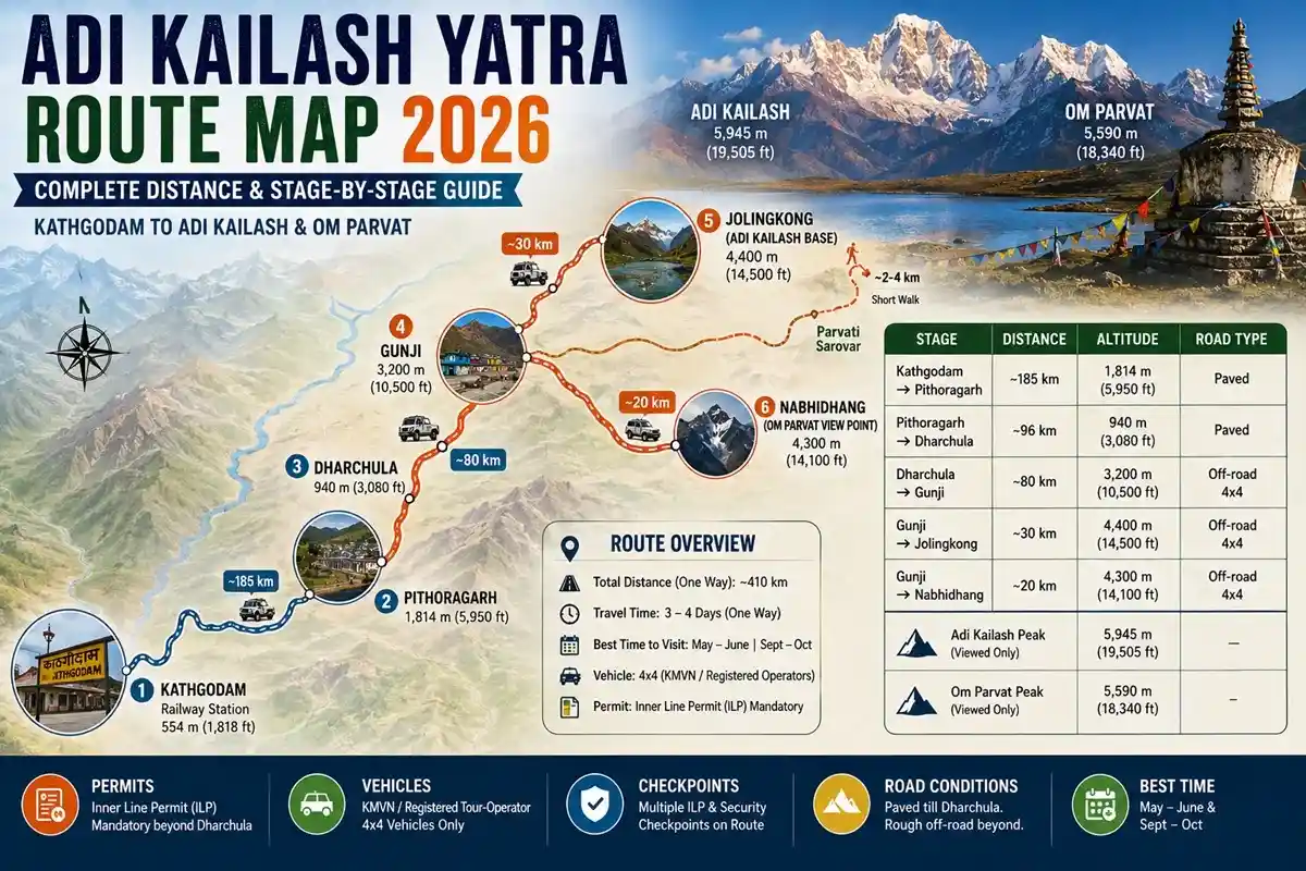
Route Overview
This travel route breaks into four legs:
- Kathgodam to Pithoragarh — paved hill road
- Pithoragarh to Dharchula — paved, last major town before the border zone
- Dharchula to Gunji — off-road 4×4, where high-altitude travel begins
- Gunji to Jolingkong or Nabhidhang — the final branch
Until BRO road construction reached Jolingkong around 2019–2021, this route needed a 200 km trek from Dharchula. Today it’s largely vehicle-based, with only short walks at the end.
Distance & Altitude Chart
| Stage |
Distance |
Altitude Reached |
Road Type |
| Kathgodam → Pithoragarh |
~185 km |
~1,814 m (5,950 ft) |
Paved |
| Pithoragarh → Dharchula |
~96 km |
~940 m (3,080 ft) |
Paved |
| Dharchula → Gunji |
~80 km |
~3,200 m (10,500 ft) |
Off-road 4×4 |
| Gunji → Jolingkong |
~30 km |
~4,400 m (14,500 ft) |
Off-road 4×4 |
| Gunji → Nabhidhang |
~20 km |
~4,300 m (14,100 ft) |
Off-road 4×4 |
| Adi Kailash peak (viewed only) |
— |
~5,945 m (19,505 ft) |
— |
| Om Parvat peak (viewed only) |
— |
~5,590 m (18,340 ft) |
— |
Figures vary slightly by source depending on whether they measure to the village center, checkpost, or road-head — treat these as realistic planning numbers. The Dharchula to Gunji distance alone accounts for most of the altitude gain on this route, roughly 2,285 m (7,500 ft) in one drive.
Gunji: Where the Route Forks
Gunji (~3,200 m) is the route’s central junction. Most pilgrims halt here for the night. From Gunji, the road splits:
- Left branch: Gunji → Kuti → Jolingkong (Adi Kailash darshan)
- Right branch: Gunji → Kalapani → Nabhidhang (Om Parvat darshan)
Most itineraries cover both branches on separate days, returning to Gunji each night rather than pushing higher without rest.
The Two Branches from Gunji
Gunji to Jolingkong: The road passes Kuti village before reaching the Jolingkong road-head. Vehicles stop here; a short walk of roughly 2–4 km (length can vary with snow) leads to Parvati Sarovar and the darshan point, with an optional stretch to Gauri Kund. Mornings generally offer clearer peak views than afternoons.
Gunji to Nabhidhang: Shorter and simpler. The Nabhidhang route runs via Kalapani, home to a Kali temple and Vyas Gufa, before reaching the vehicle-accessible Nabhidhang viewpoint. No trekking is needed here. Nabhidhang sits close to Lipulekh Pass, so expect a final security checkpoint — follow ITBP instructions.
Permits, Vehicles & Road Conditions
Entry beyond Dharchula depends on current permit conditions and district administration rules; in practice, KMVN-operated or registered tour-operator 4×4 vehicles are commonly used for this stretch rather than private cars. The route passes through an Indo-Tibetan border zone with multiple Inner Line Permit checkpoints, so carry several ILP photocopies. ILP fees are revised periodically — confirm the current fee and process with the SDM Dharchula office rather than relying on an old figure. Roads beyond Dharchula are unpaved in stretches and can be affected by landslides, especially around monsoon.
Weather & Road Status
- May–June, September–October: most reliable window; BRO has cleared winter snow
- July–August: avoid if possible — monsoon landslides are common on Dharchula–Gunji
- November–April: road generally closed by snowfall beyond Dharchula
- Fog and sudden cloud cover can affect visibility at Jolingkong and Nabhidhang any season
Facilities Along the Route
Dharchula is the last point with a reliable ATM, pharmacy, and mobile network (BSNL/Jio/Airtel). Beyond it, network coverage is patchy to absent, and ITBP posts function as informal emergency communication points. Basic medical posts exist at Gunji; serious cases are evacuated to Dharchula or Pithoragarh. Carry cash and any prescription medicines before leaving Dharchula.
Villages and Landmarks
- Kainchi Dham — Neem Karoli Baba ashram, between Bhimtal and Almora
- Jageshwar Dham — Over 100 ancient Shiva temples near Almora
- Malpa — Site of a major 1998 landslide; a memorial marks the tragedy
- Garbyang — Traditional Kumaoni wooden architecture
- Gunji — Acclimatization base and route junction
- Kuti — Last village before Jolingkong, with ruins locally called Pandav Kila
- Kalapani — Kali temple, Vyas Gufa, believed river source
Return Route
Most itineraries don’t reverse the outbound route exactly. From Gunji, pilgrims drive to Dharchula, then often branch via Didihat and Chaukori — taking in Patal Bhuvaneshwar cave temple — before rejoining the road to Kathgodam via Bhimtal. This loop is longer but offers Panchachuli mountain views.
Trekking Portions
- Jolingkong road-head to Parvati Sarovar — approximately 2–4 km, flat
- Parvati Sarovar to Gauri Kund — optional 1–2 km, slightly rockier
- Nabhidhang viewpoint — effectively no trekking required
Best Time & Latest 2026 Updates
May–June and September–October remain the best windows. A few recent developments worth noting: Gunji received the Ministry of Tourism’s Best Tourism Village Gold Award in September 2024, and in January 2025 Uttarakhand Tourism signed an MoU with ITBP allowing civilian use of ITBP helipads — improving both helicopter access and emergency evacuation options on this route.
Common Route Planning Mistakes
Reading this Adi Kailash Yatra route map before booking helps you avoid the errors that repeat every season:
- Assuming Dharchula to Jolingkong can be covered safely in one day
- Not booking a registered operator, then finding private vehicles restricted past Dharchula
- Skipping the Gunji halt to save a day, which often triggers altitude sickness
- Underestimating how weather-dependent this off-road route guide really is
Key Takeaways
- The route runs Kathgodam → Pithoragarh → Dharchula → Gunji → Jolingkong/Nabhidhang, roughly 410 km one way
- Dharchula to Gunji is the critical stage, gaining about 7,500 feet in one drive
- Gunji is the fork point for Adi Kailash and Om Parvat
- Vehicle and permit rules depend on current administration regulations — always reconfirm
- Only a short walk remains at Jolingkong; Nabhidhang needs no trekking at all
Conclusion
Understanding this Adi Kailash Yatra route map before booking changes how you plan the trip — why the Gunji night matters, why registered operators matter, and why May–June or September–October are the seasons worth targeting. Treat this itinerary map as a path guide, confirm current road status closer to your date, and the journey to Jolingkong stays demanding but manageable.
FAQs
Q1. What does the Adi Kailash Yatra route map 2026 cover?
Kathgodam → Pithoragarh → Dharchula → Gunji → Jolingkong, with a branch to Nabhidhang for Om Parvat.
Q2. What is the Dharchula to Gunji distance Adi Kailash pilgrims should expect?
Approximately 80 km by off-road 4×4, roughly 5–6 hours through the Kali river valley.
Q3. What is the Gunji to Jolingkong distance?
Roughly 30 km by road, plus a short 2–4 km walk to Parvati Sarovar.
Q4. What is the total Kathgodam to Adi Kailash distance?
Approximately 410 km one way via Pithoragarh and Dharchula, depending on measurement point.
Q5. How to reach Adi Kailash from Delhi?
Train or drive to Kathgodam, then continue by road via Pithoragarh, Dharchula, and Gunji.
Q6. Is the Adi Kailash route via Pithoragarh Dharchula the only option?
Yes — this is the sole approved road corridor; there’s no alternate motorable route into the zone.
Q7. Are private vehicles allowed beyond Dharchula?
Generally restricted by current administration rules; KMVN or registered operator 4×4 vehicles are commonly used instead.
Q8. Is the Adi Kailash route motorable, or is trekking required?
Largely motorable to Jolingkong; only a short walk remains, and Nabhidhang needs none.
Q9. Where does the route fork for Om Parvat?
At Gunji village — left branch to Jolingkong, right branch to Nabhidhang via Kalapani.
Q10. How many days does the full route take?
Most itineraries need 7–9 days from Kathgodam, including a Gunji acclimatization halt.
Q11. What is the best time to travel this route?
May–June and September–October, when roads are clear and landslide risk is lower.
Q12. How much is the Inner Line Permit fee?
Fees are revised periodically — confirm the current amount directly with SDM Dharchula.
Q13. Is mobile network available beyond Dharchula?
Rarely. Coverage is patchy to absent past Dharchula; ITBP posts serve as emergency contact points.
Q14. Is there medical help along the route?
Basic facilities exist at Gunji; serious cases are evacuated to Dharchula or Pithoragarh.
Q15. What is the altitude at Jolingkong?
Approximately 4,400 m (14,500 ft); Adi Kailash peak itself rises to about 5,945 m (19,505 ft).


 Call
Call Enquiry