Last Updated on 09/03/2026
Char Dham Yatra is a journey of utter faith and belief, held by millions of followers of Hinduism. They embark on this religiously significant pilgrimage with a desire to see their God, who is originally located in the Devbhoomi of Uttarakhand.
This guide covers in-depth information on the Char Dham route map that leads to the shrines. We hope to deliver all the necessary details about the duration, trek distance, highlights of the road, its condition, the circuit to be followed, and much more.
For better understanding, read this blog till the end.
What is the Char Dham Circuit?
The most basic question that arises in the minds of devotees is which temples exactly are collectively called the Char Dham or the Chota Char Dham of Uttarakhand.
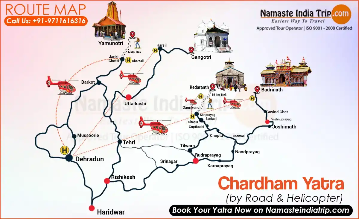
This holy Circuit involves Kedarnath, Badrinath, Gangotri, and Yamunotri.
All of these are connected to different deities and hold great relevance in Hindus culture.
1. Yamunotri Route Map
- Elevation: 3,293 m
- Holy Shrine: Maa Yamuna (2nd most pious river)
- Nearby Places to visit: Saptrishi Kund, Hanuman Chatti, Kharsali, Shani Dev Temple, Divya Shila, Janki Chatti
Yamunotri is the westernmost shrine and the first stop of the Char Dham Yatra. Situated at 3,293 m in Uttarkashi district, it is the source of the Yamuna river and home to the Yamunotri Temple dedicated to Goddess Yamuna. The last motorable point is Janki Chatti, from where a 6 km trek leads to the temple.
Distance of Yamunotri from Delhi:
| Travel |
Distance |
Time Taken |
Transportation Mode |
Major Highlights |
| Delhi – Haridwar |
240 km |
6-7 hours |
Train/ Government bus/ Private Vehicle |
Har ki Pauri, the mesmerizing beauty of the foothills of the Himalayas |
| Haridwar – Barkot |
175 km |
5-6 hours |
Rental Car/ Taxi/ Bus |
Scenic views of the valley, snow-clad mountain peaks, pine forests, Yamuna river |
| Barkot – Janki Chatti |
45 km |
1 hours 30 mins |
Shareable Jeeps/ Cabs |
Lush forests, stunning scenery of the Himalayan landscapes, hot springs, numerous waterfalls |
| Janki Chatti – Yamunotri |
5-6 km |
4-5 hours |
Trek |
Rock gardens, huge meadows, glaciers, cascading waterfalls, dense forests |
Road Conditions:
- The highway that runs between Delhi and Haridwar is very well-constructed and is dotted with all the facilities.
- The Road from Haridwar to Barkot experiences a steep ascent and frequent turns while also being narrow.
- When you drive through Barkot to reach Janki Chatti, you’ll have to come across very rough and risky terrain.
- The hike from Janki Chatti to Yamunotri Dham is steep and challenging; however, it is worth it.
Gangotri Route Map
- Elevation: 3,200 m
- Holy Shrine: Maa Ganga (The most pious river in Hinduism)
- Nearby Places to Visit: Gaumukh Glacier, Harsil, Nelong Ballet, Mukhba, Gangnani
Gangotri is the second stop of the Char Dham Yatra, situated at 3,200 m in Uttarkashi district. The temple is dedicated to Goddess Ganga (also called Bhagirathi here) and is directly accessible by road — no trek is required. The actual source of the Ganga, known as Gaumukh, lies 19 km further up the trail.
| Travel |
Distance |
Time Taken |
Transportation |
Major Highlights |
| Yamunotri – Uttarkashi |
124 km |
4-5 hours |
Jeep/ Bus/Pvt. Vehicle |
River Valleys, diverse flora, and fauna, breathtaking beauty, snow-covered peaks, Rhododendrons |
| Uttarkashi –
Gangotri |
97 km |
4.5 hours |
Jeep/ Bus/ Pvt Vehicle |
Uttarkashi town, Raithal village, Harshil, majestic charm of the waterfalls, and valleys, the charming Himalayas in the backdrop |
Road Conditions:
- It is a smooth and well-paved route between Uttarkashi and Gangotri. There may be some narrow portions, but it’s good overall.
- Still, we suggest you do not travel during the rainy season, as landslides occur in the region.
Kedarnath Route Map
- Elevation: 3,583 m
- Holy Shrine: Lord Shiva (among the 12 Jyotirlingas).
- Nearby Places to Visit: Gandhi Sarovar, Shankaracharya Samadhi, Vasuki Tal, Kedarnath Wildlife Sanctuary, Bhairavnath Temple, Agastyamuni temple.
Kedarnath is the third and most challenging stop of the Char Dham Yatra. Located at 3,583 m in Rudraprayag district, it is one of the 12 Jyotirlingas of Lord Shiva. Gaurikund is the last point accessible by road, and from there a 20 km trek (post-2013 new route) leads to the temple.
| Travel |
Distance |
Time Taken |
Transportation |
Major Highlights |
| Gangotri – Rudraprayag |
270 km |
8.5 hours |
Jeep/ Bus |
Harsil Valley, Apple Orchards, Confluence of Alaknanda and Mandakini Rivers |
| Rudraprayag – Gaurikund |
74 km |
4-5 hours |
Jeep/ Bus |
Katyayani Temple, Sonprayag, hot spring in Gaurikund and the Gauri temple |
| Gaurikund – Kedarnath |
16 km |
6-7 hours |
Trek |
Ancient Hanuman Mandir, Water stream, Meetha Paani Waterfall, Snow peaks, Jungle Chatti, Bhairavnath Temple, Sankaracharya Statue, Bheem Shila |
Road Conditions:
- The road between Gangotri and Rudraprayag is in better condition with sharp turns at some points.
- You need to drive carefully on Rudraprayag to Gaurikund as it is much narrower.
- The trek is demanding and requires you to be physically fit.
Badrinath Route Map
- Elevation: 3,133 m
- Holy Shrine: Lord Vishnu
- Nearby Places to Visit: Mana Village, Valley of Flowers, Joshimath, Hemkund Sahib, Vasudhara Falls, Tapt Kund
Badrinath is the final and most revered stop of the Char Dham Yatra. Located at 3,133 m in Chamoli district on the banks of the Alaknanda river, it is dedicated to Lord Vishnu. Unlike Kedarnath and Yamunotri, Badrinath is directly accessible by road right up to the temple gates.
| Travel |
Distance |
Time Taken |
Transportation |
Major Highlights |
| Gaurikund – Rudraprayag |
74 km |
4-5 hours |
Jeep/ Bus/ Private Vehicle |
Katyayani Temple, Sonprayag, hot spring in Gaurikund and the Gauri temple |
| Rudraprayag – Badrinath |
151 Km |
7-8 hours |
Taxi/ Cab |
Alaknanda and Mandakini confluence, beautiful en-route vistas, Vishnuprayag, |
Road Conditions:
- The connecting road between Rudraprayag and Badrinath is in doable condition and only has a few narrow turns.
How Risky is Char Dham Yatra?
The Char Dham route is set across the high mountainous regions of Uttarakhand amid harsh weather conditions. And, their challenging routes go through dense forests, steep elevations, risky terrains as well.
It certainly possesses several risks given several factors, such as:
- Some people suffer because of health issues that occur suddenly at such heights, especially respiratory and heart issues. However, you can prevent such risks by engaging in regular exercises before the trip and making yourself super fit.
- The paths of the trek are narrow, so get congested with horses, Palkis, ponies, and people, causing stampedes. Hence, we advise you to not rush and stop wherever you are at the time when the shrine receives a huge crowd.
- You may also experience sudden weather changes, natural disasters, road blockages, and such. To avoid these, always keep yourself updated on the weather conditions and plan ahead.
Char Dham Yatra Helicopter Route Map
- Indira Gandhi Airport Delhi to Jolly Grant Airport Dehradun
- Sahastradhara Helipad (Dehradun) to Kharsali Helipad (Yamunotri)
- Kharsali Helipad (Yamunotri) to Harsil Helipad (Gangotri)
- Harsil Helipad (Gangotri) to Phata Helipad (Kedarnath)
- Phata Helipad (Kedarnath) to Badrinath
- Badrinath Helipad to Sahastradhara Helipad (Dehradun)
- Jolly Grant Airport Dehradun to Delhi
Conclusion
The route map of Char Dham Yatra serves as important information for the pilgrims undertaking this holy trip. It not only helps them to plan a perfect itinerary but also allows them to choose an ideal time to visit.
Moreover, it’s a suggestion to be pre-prepared for the Yatra, the road conditions are relatively good, but you need to be aware of what is coming ahead. If you plan carefully and adhere to all the safety guidelines given by the government, this Yatra is surely going to be spiritually enriching and will fill you with memorable experiences.

 Call
Call WhatsApp
 Enquiry