

There is one detail most Badrinath pilgrims notice before they do anything else: the Badrinath weather changes its mind on the highway. The Rishikesh–Haridwar–Devprayag–Joshimath corridor is where most yatras start, get delayed, or face weather-related disruptions.
Drive into a clear sky at Rishikesh (290 m) at 6 am and you can encounter heavy rainfall or storm-like conditions at Karnaprayag (700 m) by 10 am. Reach Joshimath (1,890 m) by lunch under bright sun. Hit Badrinath (3,300 m) under a cold drizzle. That kind of swing is normal here.
The temple opened for pilgrims on 23 April 2026 on the occasion of Akshaya Tritiya. The shrine will close for winter on Bhai Dooj – expected around 13 November 2026. The final closing date is announced by the Shri Badrinath-Kedarnath Temple Committee and published on the official portal.
This guide is based on historical weather data, district advisories, and observations gathered across multiple yatra seasons. It focuses on the route, the monsoon, and the small weather decisions that decide whether you get darshan or wait at a dhaba.
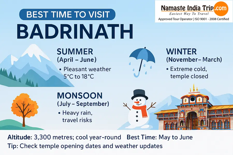
The best time for Badrinath Yatra is May to June and mid-September to October. Day temperature at the shrine stays between 12°C and 25°C. The monsoon window (July to mid-September) sees heavy rain and landslides on the Rishikesh highway – build buffer days into your itinerary.
Badrinath Weather at a Glance
| Best Months to Visit | May to June & mid-September to October |
|---|---|
| Day Temperature (peak season) | 12°C to 25°C |
| Night Temperature (peak season) | 0°C to 13°C |
| Monsoon Window | Late June to mid-September |
| Snowfall Window | December to early April |
| Tapt Kund Temperature | Around 45°C year-round |
| Altitude | 3,300 m (10,827 ft) |
| Base Town | Joshimath (1,890 m) |
| Highway Distance | Rishikesh → Badrinath: ~300 km, 10–12 hrs |
| Temple Status 2026 | Open since 23 April 2026 · Closes around 13 November 2026 |
Why Badrinath Weather Is a Highway Problem, Not a Temple Problem
Unlike most hill shrines, Badrinath Dham sits right on a national highway. You can reach it by car, bus, or shared taxi. The Alaknanda runs behind the temple, the Narayan Dhar peaks rise behind it, and the only way in and out is one corridor.
That corridor is where weather drama plays out. The 300-km drive from Rishikesh crosses five major confluences (Vishnuprayag, Nandprayag, Karnaprayag, Rudraprayag, Devprayag), four landslide-prone zones, and one of India’s most weather-sensitive mountain highways.
Three weather realities every pilgrim should know:
- Monsoon landslides cluster between Lambagad and Vishnuprayag. This 40-km stretch sees the longest traffic halts every year, sometimes 12–36 hours during peak rain.
- Joshimath has reported land subsidence since 2023. Heavy rain makes conditions worse. Stay only in approved and operational hotel zones recommended by local authorities.
- The Alaknanda swells fast. Water levels in the river can rise rapidly during intense upstream rainfall events, even when the sky over the temple is clear.
Best Time to Visit Badrinath
Peak Chardham Season: May to June
The full Chardham circuit is alive. Yamunotri opens first, then Gangotri, then Kedarnath, then Badrinath. Badrinath temperature in this window is the year’s most stable:
- Day at the shrine: 14°C to 22°C in May, climbing to 25°C by mid-June
- Night at the shrine: 4°C to 13°C
- Joshimath day: 18°C to 28°C – comfortable base camp weather
- Rain: Mostly dry in May. Pre-monsoon showers start in the last week of June.
June 10–20 is the absolute peak. Crowd, traffic, and darshan queues all hit their highest. Plan either side of this window for a calmer experience.
Second Window: Mid-September to October
The monsoon withdraws by mid-September. The skies over the Garhwal range turn postcard-clear. This is the window experienced Chardham operators quietly recommend to families who want a quieter darshan.
- Badrinath weather in September: Day 12°C to 20°C, night 5°C to 10°C. Monsoon gone. Rivers calm.
- Badrinath weather in October: Day 10°C to 18°C, night 0°C to 6°C. Cold sets in fast after sunset. First high-altitude snow on Mana Pass.
Shoulder Months: April and Early November
April: Temple is just opening. The highway is being patched. Day 5°C to 14°C. Suitable for fit travellers who want the first darshan before the rush.
Early November: Closing window. Day 6°C to 14°C. Cold snaps can close the highway overnight. Plan return with at least one buffer day.
Monsoon Window: July to Mid-September
The temple stays open, but highway conditions are unpredictable. District administrations issue daily bulletins. If you must travel, expect:
- One full day lost to road block, on average
- 2–3 night halts at Srinagar (UK), Rudraprayag, or Karnaprayag during peak rain spells
- Helicopter services paused in thunderstorms
Off-Season: November to April
Temple closed. The idol is shifted to Pandukeshwar (about 25 km downhill). Badrinath town sees 8–15 feet of snow accumulation. Temperatures touch -15°C. Not accessible for regular pilgrims. Auli ski resort (16 km from Joshimath) is the alternative winter pick.
Badrinath Weather by Month – Temperature Table
Multi-year averages at the shrine, along the Joshimath approach, and on the Rishikesh highway. Use as planning range, not daily forecast.
| Month | Day Temp (°C) | Night Temp (°C) | Highway Status | Temple Status |
|---|---|---|---|---|
| January | 0 to 7 | -12 to -3 | Closed (snow) | Closed |
| February | 3 to 9 | -10 to 1 | Closed (snow) | Closed |
| March | 7 to 13 | -8 to 2 | Border open, snow patches | Closed (pre-opening) |
| April | 10 to 16 | -4 to 5 | Partial opening | Opening window |
| May | 14 to 22 | 4 to 10 | Fully open | Open |
| June | 16 to 25 | 8 to 13 | Open, last-week showers | Open (peak) |
| July | 14 to 22 | 9 to 13 | Landslide risk, halts | Open (caution) |
| August | 14 to 22 | 9 to 13 | High landslide risk | Open (caution) |
| September | 12 to 20 | 5 to 10 | Improving after mid-month | Open (peak) |
| October | 10 to 18 | -1 to 6 | Stable, clear | Open |
| November | 6 to 14 | -5 to 4 | Closing, snow above 2,500 m | Closing window |
| December | 2 to 9 | -10 to 0 | Closed | Closed |
The Monsoon Story: Why Badrinath Weather Gets Tricky in July–August
The Chardham region sits on the windward side of the Pir Panjal and Greater Himalayan ranges. When the southwest monsoon pushes moisture up the Alaknanda valley, four things happen in sequence:
- Cloud build-up over the Rishikesh–Haridwar belt by mid-morning. Light showers first.
- Heavy bursts at Karnaprayag and Rudraprayag by afternoon. The two river confluences act as natural rain concentrators.
- Landslide activity at Lambagad, Vishnuprayag, and Chamoli by evening. Most highway halts happen here.
- Flood risk at the Badrinath approach. The Alaknanda can rise sharply in an hour during intense upstream rainfall.
One mistake many pilgrims make: assuming a clear sky at Haridwar means a clear sky at Badrinath. They are 10–12 hours apart, with five different weather zones in between. Always check the Chamoli district weather forecast, not the Rishikesh one.
Tapt Kund: The Hot Spring Next to the Temple
Right behind the temple complex sits a natural sulfur hot spring – Tapt Kund. Its water temperature stays around 42°C to 48°C through the year, even when the air outside is at 4°C. Pilgrims take a holy dip here before darshan.
What the weather does to Tapt Kund:
- Winter (closed): The kund still runs, but the path is snowed in and the area is closed.
- May to June: Pleasant outdoor bath. Air 16°C to 22°C, water 42°C+. Comfortable.
- July to August: The kund runs faster after heavy rain. Intense upstream rainfall can flood the bathing area. Sometimes the kund is temporarily closed by the temple committee.
- October: Cold air + hot water = strong sulfur steam. Magical in the morning.
Joshimath vs Badrinath – The Altitude Jump Most Pilgrims Underestimate
Most pilgrims do not realise the climb they sign up for. From Rishikesh (290 m) to Badrinath (3,300 m), the gain is over 3,000 metres in one day. From Joshimath to Badrinath alone, it is 1,400 metres – a serious altitude profile.
| Stop | Altitude | Day Temp (May) | Night Temp (May) | Suggested Stay |
|---|---|---|---|---|
| Rishikesh (start) | 290 m | 30–38°C | 20–26°C | 1 night (start) |
| Srinagar (UK) | 560 m | 26–34°C | 16–22°C | Optional halt |
| Rudraprayag | 700 m | 24–32°C | 14–20°C | Optional halt |
| Joshimath | 1,890 m | 18–28°C | 10–16°C | 1 night (must) |
| Badrinath | 3,300 m | 14–22°C | 4–10°C | Same-day return |
Pro tip: Many pilgrims try to cover Rishikesh → Badrinath → Rishikesh in two days. The body almost never agrees. Add a Joshimath night on the way up.
Best Month to Visit Badrinath – By Traveller Type
Families with Kids
Best month: May or late September. Roads are open, weather is mild, and crowds are manageable. Avoid June peak rush and August monsoon. Carry child-specific medication and extra woollens. Joshimath has higher oxygen than the shrine – acclimatise there first.
Senior Citizens
Best month: May or September. Avoid the monsoon completely. Two-night Joshimath stay (one on the way up, one on the way down). Travel with an operator offering palki and pony at the shrine. Carry prescribed medication.
NRI Families on a Short Trip
Best month: Late May or first week of October. Coincides with summer holidays (May) and Diwali break (October). Helicopter darshan available. Plan 5 nights: Haridwar (1), Joshimath (2), Badrinath (1), Rishikesh (1).
Photography Lovers
Best month: October. Clear skies, golden light, snow on Nanda Devi peak, low dust. Sunrise at Badrinath around 5:15 am in October. Tapt Kund steam at dawn is a signature shot.
What to Pack for Badrinath Weather
Badrinath is a road-and-temple destination. You do not need trekking gear, but layering is essential because the shrine altitude is real.
| Category | What to Carry | Why It Matters |
|---|---|---|
| Clothes for Darshan | Cotton kurta-pajama / dhoti for men | Tradition at Vishnu temple |
| Saree or salwar-kameez for women | Modest dress for inner sanctum | |
| Light woollen shawl | Evening aarti can be cold | |
| Base & Mid Layers | 2 thermal sets | Mornings at Joshimath are cold |
| 1 fleece + 1 down jacket | Tapt Kund dip + post-darshan cold | |
| Quick-dry innerwear | Humidity at lower altitudes | |
| Outer & Rain | Waterproof shell jacket | Highway rain can hit any month |
| Waterproof track pants | Monsoon or drizzle | |
| Poncho (cheap, packable) | Emergency cover for highway halts | |
| Footwear | Temple-friendly floaters | Barefoot inside complex |
| Walking shoes with grip | Joshimath–Mana walks | |
| Woollen socks (3 pairs) | Evenings at shrine | |
| Extras | UV 400 sunglasses + sunscreen | UV is sharp at 3,300 m |
| Small backpack (20L) | For Tapt Kund + Mana walks | |
| Personal medication + first-aid | Limited pharmacy access above Joshimath | |
| Aadhaar / photo ID | Multiple checkpoints |
Common Mistakes Pilgrims Make on the Badrinath Highway
- Trying to cover Delhi → Badrinath → Delhi in three days. The body cannot acclimatise that fast. AMS cases spike when people rush the climb.
- Checking only Rishikesh weather before leaving. The weather at Karnaprayag and Joshimath is what will decide your darshan. Always check the Chamoli district forecast.
- Treating monsoon like a normal road trip. Landslides do not announce themselves. Build buffer days into your itinerary and stay flexible on return dates.
- Booking hotels in old Joshimath without checking subsidence zones. Choose stays in the upper Auli road or Singhdhar area. Avoid zones with visible structural damage.
- Skipping the Tapt Kund dip due to cold air. The water is 45°C year-round. The dip itself is bearable even in October.
- Skipping meals on the highway. The long drive suppresses appetite. Eat at Srinagar (UK) or Karnaprayag.
Real Weather Decisions Pilgrims Ask About
What if the highway closes mid-yatra?
It happens. BRO and district PWD usually clear small disruptions within hours. Major landslides during peak monsoon can take longer, depending on the size and weather conditions. Keep 2 buffer days and stay close to your yatra coordinator for live updates.
What if my helicopter darshan gets cancelled?
Helicopter services pause in thunderstorms, fog, or wind above 35 km/h. The operator usually rebooks for the next available slot. If flying from Sahastradhara (Dehradun) or Agastyamuni (Rudraprayag), keep a backup day in Haridwar or Rishikesh.
What if my senior parents struggle at altitude?
Palki service is available at the shrine from the road head. Four bearers take about 20 minutes uphill. Pre-book through your yatra operator. Pony is the cheaper alternative.
FAQs
1. When did Badrinath Temple open in 2026?
The temple opened on 23 April 2026 on the occasion of Akshaya Tritiya. It will remain accessible to pilgrims until the Bhai Dooj closing ceremony, expected around 13 November 2026.
2. What is Badrinath temperature today?
For today’s Badrinath temperature, check the IMD Dehradun bulletin or the Chamoli district advisory. At peak season, day temperatures range 14°C to 25°C and nights drop to 4°C to 13°C.
3. What is Badrinath weather in May?
Day 14°C to 22°C at the shrine. Night 4°C to 10°C. Joshimath day 18°C to 28°C. Pleasant and dry – the start of the peak Chardham rush.
4. What is Badrinath weather in June?
Day 16°C to 25°C – the warmest month. Night 8°C to 13°C. Crowd peaks in the second week of June. Pre-monsoon showers begin in the last week.
5. What is Badrinath weather in September?
Monsoon withdraws by mid-September. Day 12°C to 20°C, night 5°C to 10°C. Clear skies, smaller crowd – often the most comfortable window.
6. What is Badrinath weather in October?
Day 10°C to 18°C, night 0°C to 6°C. Crisp autumn. First snow possible at higher altitudes by late October. Photography is at its best.
7. Is Badrinath cold in summer?
Summers at Badrinath are mild. Day temperatures reach 25°C in June, but nights always drop to single digits (8°C to 13°C). Woollens are essential after sunset, even in peak summer.
8. Does it snow in Badrinath?
Badrinath snowfall is heavy from December to March. During the yatra season, light snow at higher altitudes (Mana, Vasudhara) is possible in late October and April. The temple town itself rarely sees snow between May and October.
9. What is the best month to visit Badrinath Temple?
Best month to visit Badrinath Temple is either May (start of the season) or late September to early October (post-monsoon clarity). June is the peak but the most crowded.
10. Is Badrinath safe in monsoon?
The temple stays open, but the highway sees heavy rain and landslides. Late July to mid-August is the highest-risk window. Travel with an operator who monitors road status daily. Build buffer days into your itinerary.
11. What is the temperature of Tapt Kund?
Tapt Kund water stays around 42°C to 48°C year-round. The hot sulfur spring runs even in winter when the temple is closed.
12. How cold is Badrinath at night?
In peak season (May–June), nights drop to 4°C to 13°C. In September–October, nights fall to 0°C to 6°C. A down jacket is essential after 7 pm.
13. Can senior citizens do Badrinath Yatra?
Yes, with preparation. Stay two nights in Joshimath. Travel with an operator offering palki at the shrine. Avoid the monsoon. Carry prescribed medication and check with your doctor 30 days before.
14. Can children travel to Badrinath?
Children above 5–6 years usually manage the trip with proper layering and slow pacing. Below 5, altitude can be harsh. Avoid monsoon for kids. The Tapt Kund dip is too hot for very young children.
15. What is the altitude of Badrinath?
The shrine is at 3,300 m (10,827 ft). Joshimath is at 1,890 m. Most pilgrims add a Joshimath night for acclimatisation before the final climb.
16. Which month has the least crowd in Badrinath?
Late September to early October – clear weather, comfortable temperature, crowd is half of June. April (just after opening) is the second-quietest window.
17. What if the Rishikesh highway closes?
Small disruptions clear within hours. Major landslides during peak monsoon can take longer, depending on weather conditions. Most yatra operators reroute via Chamoli or hold pilgrims at safe halts.
18. How long is the drive from Rishikesh to Badrinath?
About 300 km. Normal drive time is 10–12 hours with one halt at Srinagar (UK) or Rudraprayag. In monsoon, the same drive can take 14–18 hours due to traffic halts.
- Suggested Tour: Badrinath Yatra Packages
 Call
Call WhatsApp
 Enquiry